Nevado del Ruiz

Nevado del Ruiz Covered in Snow: Manizales, Colombia

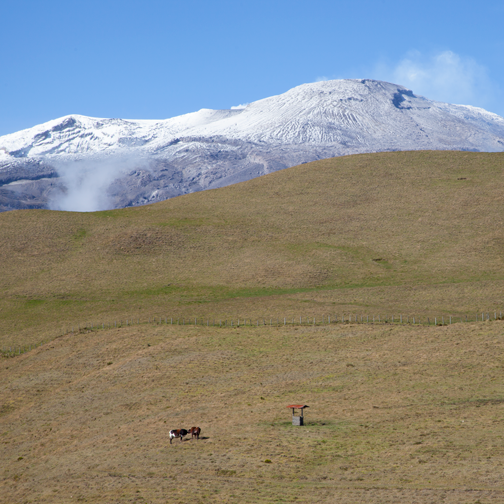
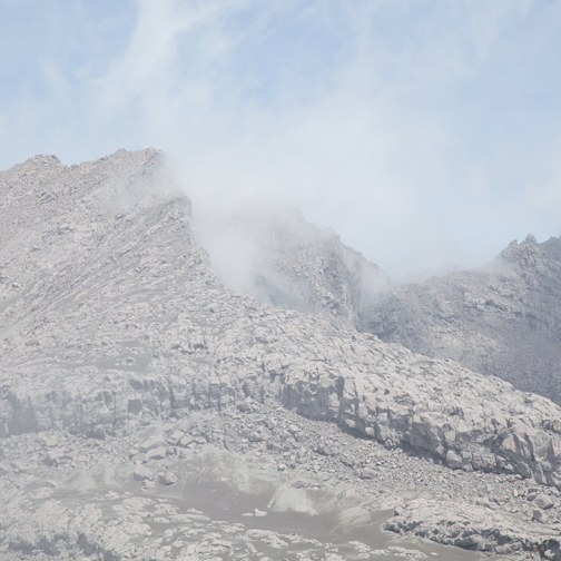
On clear days I can see Nevado del Ruiz from my apartment. This highly active volcano usually has a dusting of snow and a thick plume of ash trailing off in the wind. The ash has the same blue-grey tone that dryer lint does. I know because I sweep it off my floors every morning.

Nevado del Ruiz is one of three volcanoes in Parque Nacional Natural Los Nevados. It is the northern-most volcano and the only one currently active. For this reason, access at this end of the park is only possible with a park ranger.

Nevado del Ruiz Horses on the Murillo turn-off: Manizales, Colombia

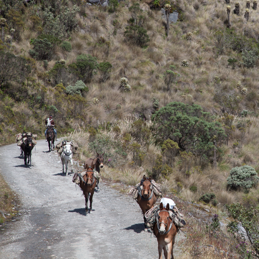
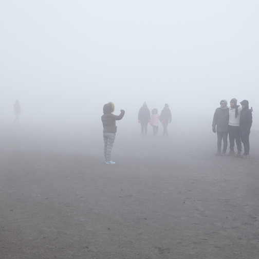
Without a car or motorcycle, a guided tour is the next best option. My sister and I filled the last two seats of a Saturday morning tour. We didn’t know it until we arrived at the meeting point at 7am, but we were in the middle of a Mexican-Colombian-American family vacation.

Our family never had vacations, so it was fun to be in the middle of someone else’s. We received snacks, Nan had a riveting discussion about horror films, and we made it into the family photos.

Nevado del Ruiz - streams at the Murillo turn-off: Manizales, Colombia

After breakfast and a canelazo pit stop (agua panela with cinnamon), we made a quick detour to Murillo. It’s a turnoff just before the park entrance. For the life of me I don’t remember why we were there except for the fact that it was beautiful.

Nevado del Ruiz  - the Murillo turn-off: Manizales, Colombia

Before we could enter the park, we had to stop at the tourist center in Las Brisas for an orientation film. Afterwards, a guide lead us up to the highest accessible location. When Nevado del Ruiz was more dormant, guests were able to go up to a lookout point. However, Valle de las Tumbas is where the tour now finishes.

Nevado-del-Ruiz-Foggy-Dirt-Road

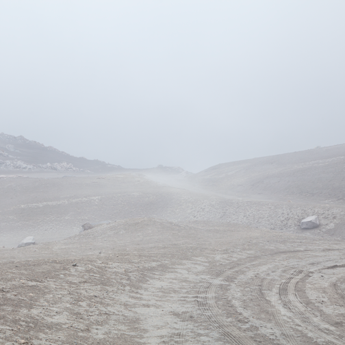
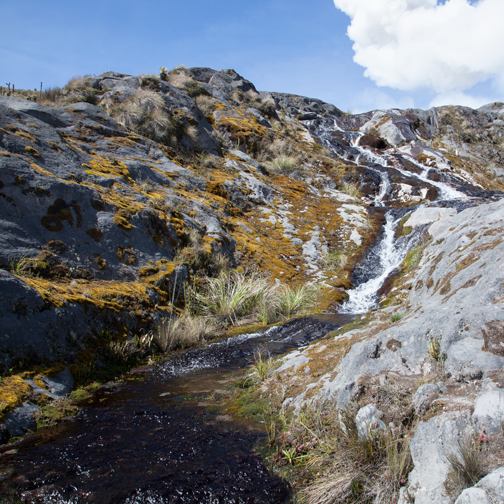
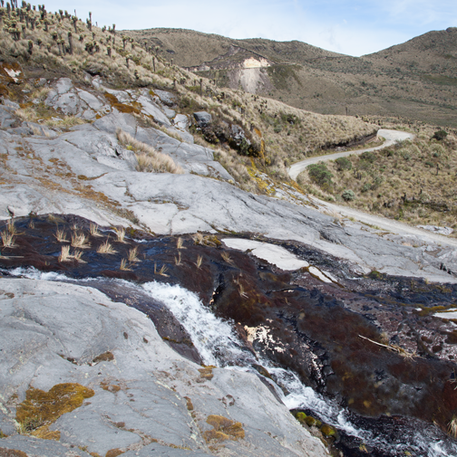
The clouds rolled in shortly after we arrived and shrouded the whole landscape. There are very few places in the world with páramo ecosystems. Not only are they gorgeous and mercurial, but they are an incredibly important source of water.

One plant that carpets the ground with dense green shoots is colloquially known as colchón de pobre, poor person’s mattress. It can hold up to 100x it’s own weight in water and is responsible for regulating the release of water in times of excess and drought.

Nevado del Ruiz - View from Valle de Las Tumbas: Manizales, Colombia

At the end of the tour we were freezing – the páramo can be very, very cold. Luckily for us the last stop of the day was the hot springs at Termales el Otoño. The water was piping hot and the view was stunning.

Nan and I both agreed it was the best family vacation we’d ever been on.

Nevado de Ruiz - View from Valle de Las Tumbas: Manizales, Colombia

About: Kumanday Hostel & Tours

About: Parque Nacional Natural Los Nevados – From the visitor center in Las Brisas, the last entrance to the park is at noon. With a Colombian cédula the entrance fee is $120,000 pesos, $140,000 without.

About: Termales el Otoño

Parque Los Nevados

Parque-los-Nevados-Rainbow

It is not easy to find information online about Parque los Nevados. Most sites direct people to day tours or overnight packages and it also doesn’t help that it’s such a large park with multiple entrances.

After talking to a lot of people I realized that a guide is only needed to access some parts of the northernmost area around the very active Nevado del Ruiz. However, guides are not required for the rest of the park, so I decided to head further south.

Parque-los-Nevados-Jeep

I organized a jeep to meet my friends and I at 7am in Villa Maria. This is a neighborhood at the end of the cable car line in Manizales. The 2.5 hour drive to Potosí wound through farm land and green fields. The difference in altitude was marked by a transition from succulent red flowers to white daisies.

Parque-los-Nevados-Hospedaje

Most jeeps head all the way up to Potosí, but Carlos must have had a deal with the occupants of Hospedaje El Bosque. He unloaded our luggage and then ran in for a quick meal before heading back down to Villa Maria. A fluffy rooster walked past the front door while the sugary smell of panela floated out from the kitchen.

We ordered breakfast and sat down in a small dining room with a TV playing in the corner. A crisp breeze blew in through the window. The landscape made me think of The Sound of Music; the telenovela in the corner reminded me I was in Colombia.

Parque-los-Nevados-Cows

From Hospedaje el Bosque, the walk uphill to the Potosí park entrance was about 1.5 hours. It was so tranquil that the wind blowing over the mountains sounded like a distant river. When I stopped to open a snack, the plastic bag sounded like a jumbo jet passing overhead.

The park stops admitting visitors after 1pm. Luckily we made it there within minutes of closing time. The good news was that with our Colombian cédulas we received the locals’ rate – 9,500 pesos. Foreigners without this card have to pay 27,000 pesos. There was no extra fee for camping.

The bad news was that our destination, El Cisne, had been closed for about 5 years. That was really confusing because I knew I’d looked up the hotel and camping rates on their website within the last six months. I’m certain of that!

Parque-los-Nevados-Path

We changed our destination to a campsite at Laguna del Otún. It was a 4.5 hour hike that I had not been expecting. We were all also coming to terms with the scant amount of food we brought because our original destination, El Cisne, would have had a restaurant. My backpack was filled with wine instead of carbs and protein.

Parque-los-Nevados-Horse

I was definitely feeling the páramo altitude and the blisters that were starting to form on my feet. The sun was bright and I later realized that I had covered everything except for the backs of my hands. Every now and then we heard a rumble on the trail and jumped out of the way just in time for a group a packhorses to pass.

Parque-los-Nevados-Lago-Otun

Halfway through the hike we reached the highest point of the trail, which overlooked Laguna del Otún. Golden grasses lined the slope down to the lakefront. Off in the distance a single cascade coursed down the steep rock face.

Parque-los-Nevados-Frailejones

We were at about 3,950 meters when further along the path we passed through a field of frailejones. A light afternoon shower began and in the process created a double rainbow over the lake.

For dinner we found a small BBQ grill and seven of us split half a loaf of bread, a package of sliced something, and two bottles of wine. We went to bed when the frigid winds were too much too handle. Our sleeping bags were warm, but the wind continued playing with out tent all night.

Parque-los-Nevados-Sulphur-Vent

The next morning we relaxed around the campsite. Some people hiked uphill for a view of Santa Isabel. My blisters were too painful, so I chose a level walk around the north end of Laguna del Otún. At one point I came across a hill with a series of sulphur vents.

Because we were down to very little food, we decided not to camp a second night. We walked back and stayed at the Parquedero in Potosí. It was a basic building with a layout similar to a tiny motel. The guest rooms were completely empty of furniture and the communal bathroom didn’t have a faucet. The toilet handle was a rough green string.

The only place to wash hands was in the warm kitchen, where all the locals congregated on benches along the wall. They served us caldo, arepas and dark, dark agua panela for 4,000 pesos. For dinner we ate eggs, rice, a buttery arepa and hot chocolate for 6,000 pesos.

Parque-los-Nevados-Hospedaje-Campsite

Now that we were finally full, we headed out back where we had pitched our tents. The moon was so bright it was like a spotlight. My sharply outlined silhouette stretched across the paddock grass.

The following morning, the family who ran the Parquedero was already cooking by the time I woke up. The radio was on and the benches that lined the wall were filled. I sat on a grassy slope outside and watched thick white ash blow out of a vent on the kitchen roof.

Home is where the hearth is. I wondered if there was a Spanish equivalent for that.

Parque-los-Nevados-Farm

Curacao: Week 253

Polaroid of a pink building in Otrobanda: Willemstad, Curacao

Curacao is the largest member of the ABC Islands (Aruba, Bonaire, and Curacao). It has a much more European feel than Aruba, which could partially be attributed to the beautifully preserved UNESCO area of Willemstad.

If you were to imagine a horseshoe pointing downwards, historic Willemstad would be the two ends. Both ends make for an impressive entrance to Schottegat Bay and are connected to each other by the retractable Queen Emma Bridge. Cruise ships, Venezuelan fishing boats, and oil refinery traffic pass through the bay daily.

Vintage postcard of Punda: Willemstad, Curacao

We spent the morning walking through the Otrobanda side of the harbor before crossing the pedestrian bridge to Punda. The waterfront colonial buildings in Punda are probably the most common postcard image of Curacao.While they looked beautiful, the businesses housed a few too many tourist traps for our liking.

For something a little more interesting, we walked one neighborhood over to Nieuwestraat in Pietermaai. It was less touristy and filled with lots of delicious restaurants like Mundo Bizarro. Their vanilla lemon sorbet was incredible.

Curacao is also famous for the failed Valencia oranges that the Spaniards brought over during the early days of colonization. The island turned out to be far too arid and dry, so the trees were left to their own devices. It was only much later that someone discovered the wonderful aroma of the dried peels.

We were on our way to the Curacao Liqueur Distillery, famous for using the offspring of the original oranges, when we accidentally ended up outside the Zuikertuin Mall. I was trying to figure out where we went wrong when we noticed a large, open-air cafe.

There was freshly baked bread on the first floor and a cool breeze on the second. The backyard was filled with tall trees, peacocks and roosters. After some coffee and beer we did eventually find our way to the distillery, but it wasn’t as nice as our accidental find.

Blue iguana at Christoffel National Park: Curacao

Christoffel National Park is on the north end of the island. It was an hour’s drive via a quiet road peppered with iguana sightings. Of the two trails available, we picked the coastal loop. Because of the early afternoon heat, walking the loop was prohibited. We had to drive to the sites, but that didn’t prevent us from seeing massive ice-blue iguanas under bushes and in trees.

Coin purse from Jaanchie's: West Punt, Curacao

Rounding out the north end of the island is a small town called West Punt, where Jaanchie’s was located. The first thing we noticed when we walked in was the birds. A hundred little yellow bodies darted in and out of the porch feeders. The volume of the birdsong was incredible and their rapid, jittery movement was mesmerizing.

We quickly discovered that Jaanchie’s is the kind of place you don’t want to rush. The beer is very cold and the only menu can be found in the owner’s head. When Jaachie’s ready to list the options, he’ll pull up a chair.

“Who are the couples?” Jaanchi asked before walking two fingers up Jen’s arm. “Iguana is supposed to be very good for couples.”

We each ordered a different dish and decided to share a plate of iguana, which ended up tasting like really good chicken wings. The meals were served in metal trays.

My goat stew was flanked by salad on the right and beans and rice on the left. The only seasoning on the table were three little bowls of diced onions, tartar sauce and mayo. Jaanchie’s has been on the tourist trail for decades, so its prices reflect that, but the food is definitely worth it.

The blue waters of Grote Knip cove beach: Curacao

Playa Abou (AKA Grote Knip) is a popular beach cove close to West Punt. The cliffs overlooking the crystal clear water are covered in cacti while trees and thatched pergolas shade the beach. The mustard yellow hue of the rocks reminded me of Australia.

That’s how I knew we’d found a little bit of heaven in the ABC Islands.

Dinner and sunset on the beach at Pirate's Bay: Curacao

About: Curacao

How to get to Mundo Bizarro: Nieuwestraat 12, Willemstad

How to get to the Curacao Liqueur Distillery: Elias R A Moreno Blvd, Saliña Ariba, Willemstad

About: Christoffel National Park

How to get to Jaanchie’s: Westpunt 15, Westpunt Curacao

About: Grote Knip

Sunset over the ocean at Pirate's Bay: Curacao

Aruba: Week 252

The blue waters of Malmok Beach: Aruba

Aruba is a very arid island. The contrast between tropical Caribbean dreams and the desert landscape couldn’t be any starker than it is on the coast, where cacti grow straight out of white beach sand.

The sheltered SW side of the island is famous for its beaches and snorkeling. Barret and I spent our first morning at Malmok Beach, which is smaller and quieter than the resort beaches further south.

A large iguana lounged against a white wall while turquoise-speckled Aruban Whiptails scurried out from the shadows. One accidentally grazed the top of my hand with its soft underbelly and scratchy nails.

Turquoise-spotted Aruban Whiptail lizard: Aruba

Along the coast pelicans swooped into schools of fish while small boats cast their anchor further out. The tour boat blasting dance music was named Putin Pleasure. I blinked twice and realized the palm tree logo in the font was meant to spell out Palm Pleasure.

View of the Boca Prins Beach: Arikok National Park, Aruba

The NE side of Aruba has pounding waves and a jagged coastline reminiscent of shards of glass. A good portion of this coastline belongs to the Arikok National Park. The relentless sun beats down year round and is the reason only stray goats cross this desert landscape on foot. A rental car is the best way to visit to Arikok.

Desert landscape at Arikok National Park, Aruba

View of the coast at Arikok National Park, Aruba

Mikayla at Arikok National Park, Aruba

Cave art at the Fontein Cave: Arikok National Park, Aruba

The coastline north of the national park is unpopulated and largely difficult to reach without 4WD. The Bushiribana Gold Mill Ruins is one of the few buildings that sits along this stark coast and is accessible by a paved road.

View from the Bushiribana Ruins: Aruba

The mill was built in the late 1800s and was in use until being replaced by the Balashi Mill on the other side of the island. Balashi operated until WWI, when the imported mining materials became impossible to secure. After the war, the neglected mill was in such a state of disrepair than no further production was pursued.

Collapsed Natural Bridge: Aruba

Close to the ruins is the former location of Natural Bridge. As its name suggests, it was a strip of land that spanned across a rugged cove. Although nature eventually had its way and the bridge collapsed, tourism still prevails.

A wooden ladder has since been constructed which allows people to access a small, protected pool during low tide. My friends and I happened to be there during high tide and it was one of those moments where I could imagine the following day’s headline: Security measures to be proposed in wake of tourists being dragged out to sea.

Driftwood folk art from Aruba

Leaving the ruins, along the single paved road, was my favorite gift shop on the island. It was actually a wooden shed on private property, but it had a massive collection of driftwood painted to look like colorful fish. It was folk art at its purest and I didn’t see anything like it near the cruise ship docks.

Cacti sunset near the Alto Vista Chapel: Aruba

Cacti sunset near the Alto Vista Chapel: Aruba

The Alto Vista Chapel can also be found on the desolate NE coast. It was built upon the location of the island’s first Roman Catholic Church. While the building itself attracts tourists and Tuesday evening service-goers, the most compelling reasons to visit are the sunsets and the footpaths through the cacti-filled landscape.

Alto-Vista-Chapel-Sunset-Walk

Exterior view of the National Archaeological Museum Aruba - Oranjestad

Downtown Oranjestad, with its colonial architecture, is actually quite small. Aside from a spattering of museums, retail shops dominate the landscape. The National Archaeological Museum, which is free to the public, is located inside the former Ecury Complex.

Anthropomorphic ceramic jar from the National Archaeological Museum Aruba - Oranjestad

Pottery shard from the National Archaeological Museum Aruba - Oranjestad

The buildings, some of which date as far back as the 19th century, remained in the Ecury family until 1997. Today, the complex is a modern museum with a focus on Aruban Amerindian culture and the country’s colonial heritage.

Street art in Oranjestad, Aruba

Colonial building in Oranjestad, Aruba

Papiamento and Dutch are the two official languages, but Aruba is much more linguistically savvy than that. Because the island receives a significant amount of tourism from the US, English is very widely spoken.

Most of the ATMs dispense US dollars and stores usually expected me to pay in USD. I, of course, took all my money out in Florins and every time I went to the store I felt like the kind of tourist that wears a beret in Paris.

Chinese restaurant in Oranjestad, Aruba

Spanish is also understood because of the close proximity of Venezuela and it’s hard not to notice that most of the independent groceries stores reflect Chinese ownership.

Polaroid of a pink bungalow house in Aruba

Outside of Oranjestad’s historical area, the majority of homes are one-story bungalows. They come in an array of colors and would not have been out of place during the 1950s.

After a few days of driving around the island, I thought about the couple at the airport that passed through immigration before us. This was their 28th visit to Aruba and they were excited to be back.

No matter how much I’ve enjoyed a destination, I’ve never felt that strongly about one place. I liked Aruba and I loved the desert sunsets, but the One Happy Island was a little too small and commercial for me. I’d dipped my toes into Aruba and it just left me curious about all the other Caribbean islands. Good thing we’d already planned on jumping over to Curacao.

Polaroid of the road leading to the Alto Vista Chapel in Aruba

About: Alto Vista Chapel

About: Bushiribana Gold Mill Ruins

About: Arikok National Park

About: National Archaeological Museum Aruba

Polaroid of a tangled cactus in Arikok National Park: Aruba

The Hike to La Gruta: Week 240

The foggy route to La Gruta and Parque los Nevados: Manizales, Colombia

I play volleyball with my SENA colleagues twice a week after work. The volleyball court is across the road from the campus and is reached via an underground tunnel. From here, the view of the school and the hills and the mountains that rise up behind is absolutely stunning.

Sometimes the view is so pretty, especially during a sunset, that I have a hard time concentrating on the game. For this reason, when some friends of ours wanted to hike the mountains nearby SENA, I was excited. I knew how scenic the area was.

We caught a buseta that went through Gallinazo and exited at a fork in the road. To the right was a hot springs complex and to the left was a narrow road that eventually led to the volcanoes and the páramo of Parque Los Nevados.

The foggy route to La Gruta and Parque los Nevados: Manizales, Colombia

Aside from a few bicyclists and motorcyclists, the bumpy uphill road was quiet. As we walked the morning fog moved in. Birds called out from the surrounding trees and rivulets of water trickled down the side of the road. The landscape was so peaceful that it was easy to forget how much volcanic activity was underneath our feet. Nature can be deceiving like that.

When we stopped for water Barret heard a strange noise. It sounded like a lid bouncing on top of a pot of boiling water. He searched the side of the road until he found a small vent – a hint of the volcanic activity below. The gurgling was punctuated by a puff of steam that dissipated as silence fell. A few seconds later the gurgling began again.

After four hours of walking uphill, we reached our destination- La Gruta. Outside the grotto was a memorial to a group of Boy Scouts that were killed there in 2006. They had hiked up the very route we had just taken and were swimming when a surge of water suddenly appeared and swept them away.

The waterfall at La Gruta, just off the route to Parque los Nevados: Manizales, Colombia

The clouds hung low the afternoon of our visit. The waterfall was at the far end of the grotto and closer to the entrance was a pool of hot, steamy water that poured out of the rock face. The water that flowed out of the grotto passed under a bridge before heading down the mountain.

The thermal water at La Gruta, just off the route to Parque los Nevados: Manizales, Colombia

Down the road from the bridge was the only building we had come across on our four-hour hike. A man walked out from an open door and asked us if we wanted a cup of aguapanela or an arepa. We had brought our own food, so we declined and continued walking until we reached a small outdoor hot springs.

The hot spring just of the road to Parque los Nevados: Manizales, Colombia

We passed through a metal gate and asked the caretaker if we could eat lunch atop the sloping hill. Below us was a small concrete pool filled with thermal water and the remnants of a second pool. A long green hose poured cool water into one end of the pool while piping hot water flowed into the other end.

The small hot spring on the way to Parque los Nevados: Manizales, Colombia

When a group of four left the hot spring, we walked down the grassy slope and changed into our bathing suits. The afternoon was foggier than ever when we got into the water. My cold feet began to tingle and my tired shoulder muscles slowly relaxed.

Swimming in the small hot spring on the way to Parque los Nevados: Manizales, Colombia

Every now and then I saw the caretaker strolling the hill above; he was a poncho-clad silhouette in the fog. If it weren’t for the steep terrain, I would have thought we were in the British moors.

On the way back down a jeep pulled over and offered the four of us a ride back into town. We jumped in and tucked our legs up on a hard plastic kennel. Metal beams crisscrossed the ceiling of the jeep and I crouched down so that my head wouldn’t hit the roof every time we bounced over a rock. Including us, there were nine adults, one baby, and one dog in the car.

It felt like we were hitching a ride in the middle of nowhere, hundreds of miles from the nearest city. However, within the hour we were dropped off at a gas station across from the Manizales bus terminal. Moments like that are when I feel very lucky to live in Manizales.

The path to access La Gruta, on the way to Parque los Nevados: Manizales, Colombia

Blog at WordPress.com.